Thursday, June 16, 2011

A Look Back at 2011

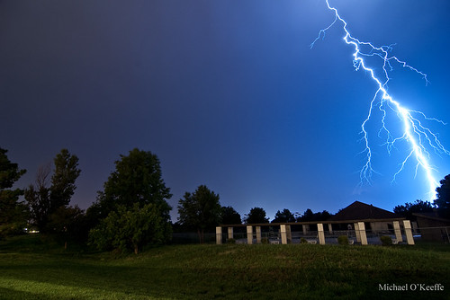
Well the 2011 season looks to be coming to a close for us and it was a good one with a record low amount of chasing but a solid number of tornadoes considering. A lot of first including my first Iowa tornado and my first solo tornadoes in another state. Below are some stats on the year and the best pictures of the year.

2011 Storm Chase Stats:
Chase Days: 4
States Chased: NE, IA, KS, OK
Tornado Days: 2 (April 9, May 24)
Tornadoes: 5
Strongest Tornado: EF3 (April 9-Mapleton, IA & May 24-Canton, OK)
Bust Days: 2 (April 14, May 11)
Overall Rating: 5/10

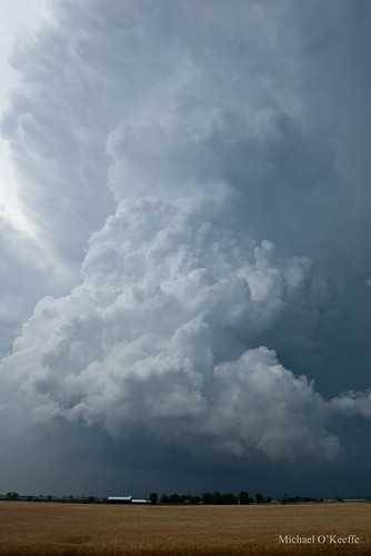
April 9 - The first chase of the season took us to NW Iowa where we bagged a large dusty EF3 tornado that did significant damage to the small town of Mapleton, IA.
4/9/11 Mapleton, IA Violent Tornado

April 14 - Was a solo chase that took me to the KS/OK border where my hestitation cost me a tornado near Burbank, OK and too much storm interaction killed the rest of the day. All I was able to muster was some brief supercell structure near Hominy, OK.
4/14/11 Osage County, OK Supercell

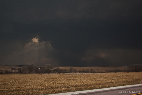
May 11 - Unexpected morning convection over the TX Panhandle moved into the target area destroying the day and I knew that would be the case but still went out hoping that maybe there could be enough destabilization in the wake of the storms but that was not the case. Major bust in SW Kansas.
The High Plains of Kansas

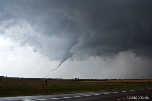
May 24 - The chase of the year took me to Oklahoma for a major High risk chase day. I was solo and a bad road option cost me most of the Canton wedge with just a short view of the last few minutes of the tornado south of Longdale. I was able to redeem myself with a few more weak tornadoes followed by a beautiful rope tornado south of Fairview that gave my best tornado photos I have ever taken!
5/24/11 Fairview, OK Tornado

June 10-12 - Myself and a few friends went down to Joplin over the weekend to assist with disaster relief. The devastation was unbelievable only comparable to what I saw in Greensburg but over a larger more populated area. We assisted with food distribution to tornado victims as well as field work removing and sort through debris. It was one of the more memorable experiences of my life.
Joplin, MO EF5 Tornado Damage

Wednesday, May 25, 2011

May 24, 2011 NW Oklahoma Tornado Video Stills

Below are video stills of yesterday's tornadoes that I intercepted in NW Oklahoma. There is also a video uploading now that I will post shortly.


And another photo of the Fairview tornado.
5/24/11 Fairview, OK Tornado

Tuesday, May 24, 2011

Amazing Chase in Oklahoma Today!

I intercepted 4 tornadoes today between Canton,OK and Fairview,OK. The first was a large wedge that unfortunately I showed up a bit late too and only saw the end of it from about 3-4 miles away. I only have video of this tornado. The second tornado was a elephant trunk tornado that lasted only a few minutes. The third was a brief little cone tornado with a small debris cloud and the last tornado was a gorgeous long rope tornado that lasted near 5 minutes just south of Fairview. I then had problems with the Delorme and made a few wrong turns keeping me too far from reaching the OKC action and I didn't feel like driving all the way back down there even though I regret that decision now. I am very happy with my results regardless today minus being late to the Canton beast!
5/24/11 Fairview, OK Tornado
5/24/11 Fairview, OK Supercell

Looks like more action this weekend hopefully we can get out because it could be HUGE! Also keep OKC in your thoughts and prayers as many areas hit last year on May 10 and May 3, 1999 have been hit again by violent tornadoes.

High Risk Chase Today!

A major outbreak of tornadoes appears likely today over SC KS/C OK as a high risk has been issued by the SPC. Long track/violent tornadoes and monster hail will be serious threats with potentially long tracked cyclic supercell thunderstorms. Right now I am liking the KS/OK border region around I35 but they could change as I take a look at later RUC runs and HRRR data.

Monday, May 23, 2011

Big Time Severe Weather Tomorrow!

Tomorrow looks absolutely huge across C KS/C OK as a powerful trough blast into the region. 70f dews with 4000j/kg of CAPE with near perfect large hodographs will provide a very volitle enviornment for monster supercells with gorilla hail and strong tornadoes. I have a good feeling about this one as I will be out tomorrow for sure!

Monday, May 16, 2011

Active Pattern Ahead!

I haven't posted on here in a while because well there hasn't been much to post about. Outside of a major "I saw it coming but went out anyway" bust in SW Kansas I haven't been doing much chasing because there really hasn't been much to chase. Fortunately though that looks to change very soon. This week I am incredibly busy with school and graduation so I can't get out at all this week but my dad will be out on Thursday in W/C Kansas where things look to be shaping up for a big event anywhere from Hill City to Coldwater into Oklahoma. There is a very slight chance I can chase on Friday closer to home in E Kansas but that depends on when the days events get done with. Then on Monday May 23 and Tuesday the 24th both look HUGE over the C/S Plains again and I WILL be chasing these events which I am very much looking forward too. After that the models are back and forth so who knows but it is nice to finally see some classic severe weather setups moving into the Plains.
The High Plains of Kansas

Sunday, April 17, 2011

April 14 and The Rest of April

4/14/11 Osage County, OK Supercell
Above is a supercell I intercepted just south of the KS/OK border in Osage County on April 14 on a day I largely want to forget. Too much hesitation on my part trying to decide which storm to intercept cost me the Burbank tornado missing it by minutes. The storm quickly went to crap shortly after I arrived from what appeared to be from too many storms and weak winds at the mid levels. I wouldn't liked to have been in SE Oklahoma where stronger upper level winds were and the were the jet stream had a nice divergence but time kept me further north.

This system was incredible producing near 250 tornado reports between April 14-16 from KS/OK to MS/AL and NC/SC/VA. This was a historic outbreak for sure!

Looking ahead there is a couple of systems moving in on Tuesday and Friday but neither look very good chase wise but severe weather is likely. The last week in April though is looking appetizing in the long range with several potent setups over the S Plains. Very far out now but this time of the year the long range is typically quite accruate depicting a general trend in which this case is several severe weather setups.