Well the 2011 season looks to be coming to a close for us and it was a good one with a record low amount of chasing but a solid number of tornadoes considering. A lot of first including my first Iowa tornado and my first solo tornadoes in another state. Below are some stats on the year and the best pictures of the year.
2011 Storm Chase Stats: Chase Days: 4 States Chased: NE, IA, KS, OK Tornado Days: 2 (April 9, May 24) Tornadoes: 5 Strongest Tornado: EF3 (April 9-Mapleton, IA & May 24-Canton, OK) Bust Days: 2 (April 14, May 11) Overall Rating: 5/10
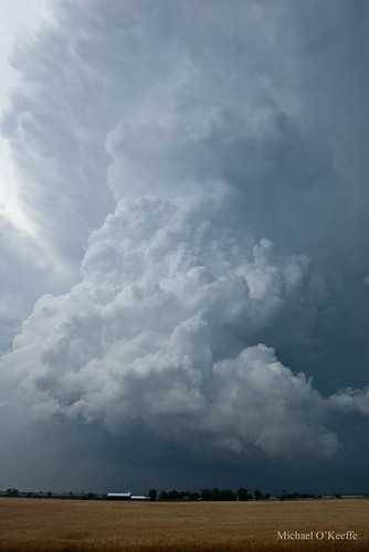
April 9 - The first chase of the season took us to NW Iowa where we bagged a large dusty EF3 tornado that did significant damage to the small town of Mapleton, IA.
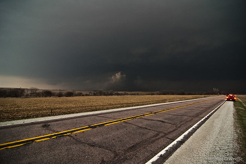
April 14 - Was a solo chase that took me to the KS/OK border where my hestitation cost me a tornado near Burbank, OK and too much storm interaction killed the rest of the day. All I was able to muster was some brief supercell structure near Hominy, OK.
May 11 - Unexpected morning convection over the TX Panhandle moved into the target area destroying the day and I knew that would be the case but still went out hoping that maybe there could be enough destabilization in the wake of the storms but that was not the case. Major bust in SW Kansas.
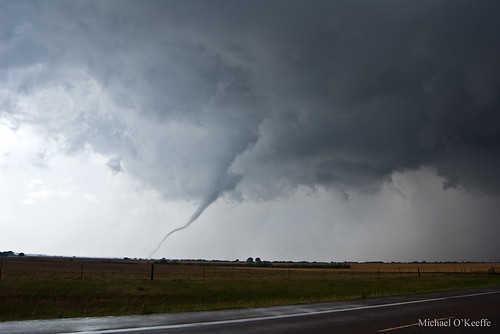
May 24 - The chase of the year took me to Oklahoma for a major High risk chase day. I was solo and a bad road option cost me most of the Canton wedge with just a short view of the last few minutes of the tornado south of Longdale. I was able to redeem myself with a few more weak tornadoes followed by a beautiful rope tornado south of Fairview that gave my best tornado photos I have ever taken!
June 10-12 - Myself and a few friends went down to Joplin over the weekend to assist with disaster relief. The devastation was unbelievable only comparable to what I saw in Greensburg but over a larger more populated area. We assisted with food distribution to tornado victims as well as field work removing and sort through debris. It was one of the more memorable experiences of my life.
I intercepted 4 tornadoes today between Canton,OK and Fairview,OK. The first was a large wedge that unfortunately I showed up a bit late too and only saw the end of it from about 3-4 miles away. I only have video of this tornado. The second tornado was a elephant trunk tornado that lasted only a few minutes. The third was a brief little cone tornado with a small debris cloud and the last tornado was a gorgeous long rope tornado that lasted near 5 minutes just south of Fairview. I then had problems with the Delorme and made a few wrong turns keeping me too far from reaching the OKC action and I didn't feel like driving all the way back down there even though I regret that decision now. I am very happy with my results regardless today minus being late to the Canton beast!
Looks like more action this weekend hopefully we can get out because it could be HUGE! Also keep OKC in your thoughts and prayers as many areas hit last year on May 10 and May 3, 1999 have been hit again by violent tornadoes.
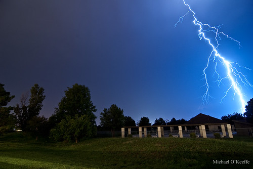
A major outbreak of tornadoes appears likely today over SC KS/C OK as a high risk has been issued by the SPC. Long track/violent tornadoes and monster hail will be serious threats with potentially long tracked cyclic supercell thunderstorms. Right now I am liking the KS/OK border region around I35 but they could change as I take a look at later RUC runs and HRRR data.
Tomorrow looks absolutely huge across C KS/C OK as a powerful trough blast into the region. 70f dews with 4000j/kg of CAPE with near perfect large hodographs will provide a very volitle enviornment for monster supercells with gorilla hail and strong tornadoes. I have a good feeling about this one as I will be out tomorrow for sure!
I haven't posted on here in a while because well there hasn't been much to post about. Outside of a major "I saw it coming but went out anyway" bust in SW Kansas I haven't been doing much chasing because there really hasn't been much to chase. Fortunately though that looks to change very soon. This week I am incredibly busy with school and graduation so I can't get out at all this week but my dad will be out on Thursday in W/C Kansas where things look to be shaping up for a big event anywhere from Hill City to Coldwater into Oklahoma. There is a very slight chance I can chase on Friday closer to home in E Kansas but that depends on when the days events get done with. Then on Monday May 23 and Tuesday the 24th both look HUGE over the C/S Plains again and I WILL be chasing these events which I am very much looking forward too. After that the models are back and forth so who knows but it is nice to finally see some classic severe weather setups moving into the Plains.
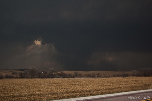
Above is a supercell I intercepted just south of the KS/OK border in Osage County on April 14 on a day I largely want to forget. Too much hesitation on my part trying to decide which storm to intercept cost me the Burbank tornado missing it by minutes. The storm quickly went to crap shortly after I arrived from what appeared to be from too many storms and weak winds at the mid levels. I wouldn't liked to have been in SE Oklahoma where stronger upper level winds were and the were the jet stream had a nice divergence but time kept me further north.
This system was incredible producing near 250 tornado reports between April 14-16 from KS/OK to MS/AL and NC/SC/VA. This was a historic outbreak for sure!
Looking ahead there is a couple of systems moving in on Tuesday and Friday but neither look very good chase wise but severe weather is likely. The last week in April though is looking appetizing in the long range with several potent setups over the S Plains. Very far out now but this time of the year the long range is typically quite accruate depicting a general trend in which this case is several severe weather setups.
Today is looking like a potentially volitle day over much of E Kansas and E Oklahoma. I am really liking the KS/OK border area where 60F dews seem likely with good Cape and it is close to the stronger LLJ with 50knts out of the SE really making me smile. Even upper 50 dews can get the job done today and with the RUC and HRRR agreeing with this I think today could be good! I will be leaving around noon for my target.
Great day in Iowa that we could've done a bit differently but I'm satisfied none the less! We left Olathe, KS at 10:30am with a target of Fremont, NE. We met up with Brandon Sullivan, Conner McCrorey, Donovon Gruner, and Brett Wright. We hung out just west of town and waited for storms to fire. Towers began going up just to our west so we went our seperate ways and went after them. We were sitting right under the storm when it developed and we were ahead of it as it slowly matured into a powerful supercell as it crossed the Missouri River west of Onawa, IA. Inflow was intense by now with winds sustained around 40MPH.
As we entered Onawa we were stopped by a train crossing the road and we quickly looked back to see a classic RFD/clear slot and rapid rotation on the wall cloud. The train moved on in the nick of time and we found a good spot just east of town to watch the now beast of a storm. Inflow continued to be insane and rotation was increasing in the middle of the supercell giving the storm a classic donut hole look. A fire possibly started by lightning was being pulled towards and upwards into the area of rotation just as a debris cloud began churning under the rotation. It quickly grew as a small funnel developed above it. Now I am not sure if this was a tornado or gustnado but for the sake of avoiding a flame war lets just call it a "tornadic" gustnado(?) I don't know what ever it was, it was pretty cool!
Classic structure as the supercell moves over Onawa.
Gustnado just east of Onawa.
After moving east then north then east again we watched the storm cycle and get ready to produce again. The structure was pretty textbook of a strong tornadic supercell with a nice rounded base and several fast moving inflow tails with a nice clear slot on the backside. Soon a small nub funnel was seen to our north with what looked to be a large debris cloud underneath. We filmed it for several minutes as we tried to decide if it was a definite tornado and we were sure it was. We wanted to reposition to the north to get better visibility of the tornado and as we did the debris cloud really grew completely enshrouding the small cone funnel above it in dust. We got a nice view of the tornado once we found our north option and the thing was a large dusty mass. We didn't know it at the time but it was going through Mapleton at this time. We watched it dissipate before repositioned again to our east then north. Once dark fell we took a few lightning pictures and decided to call it a day since we had a 4 hour drive ahead of us and it was already after 8pm. We were a little dissapointed about missing the nighttime tornadofest but what can you do. At least we got to chase! I was more dissapointed about not being east or NE of the tornado like I like to be typically but at least I saw the tornado! We ended up back home around 1am.
Classic structure looking NNW, you can see the Mapleton tornado developing just right of center.
We nailed at least one large tornado today near Mapleton, IA in the NW part of the state that unfortunately did significant damage to town. Below is a quick teaser with more to come in the coming days.
Today begins the first chase of 2011 for my dad and I as we are heading north to W Iowa and E Nebraska to play a potent yet slightly capped setup. I have a feeling in my gut storms will be able to initiate today and if that happens with the strong instability, deep moisture, warm front, and classic shear profiles supercells with tornadoes are a good possibility. The 6z NAM, GFS, and HRRR all break out precip near the triple point in NE Nebraska so we will likely sit just along the river possibility as far north as Sioux City depending on where the warm front ends up.
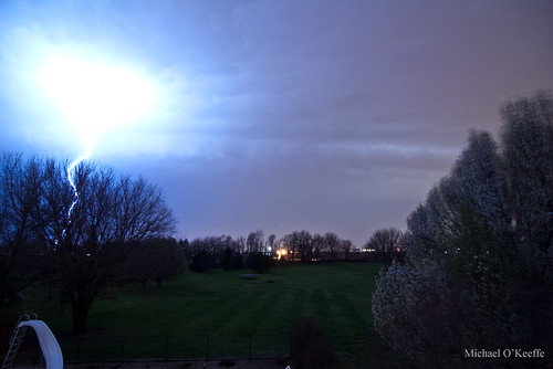
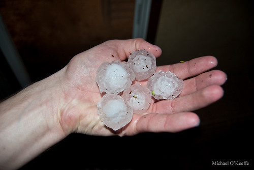
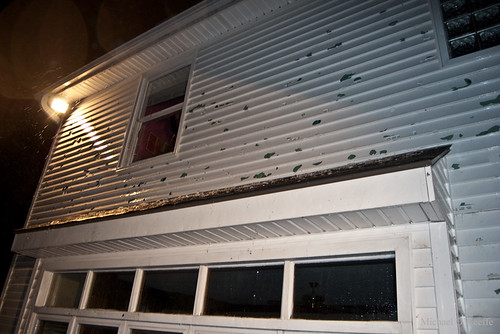
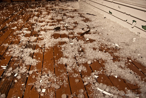
Last night we were slammed by an elevated severe storm that dumped golfball sized hail right here at our house in Olathe, KS down SW of Kansas City. The hail however caused significant damage to our house with the entire west facing side of our house completely blasted with large holes in the siding, major roof damage, as well as several busted windows, luckily we had the cars in the garage! It was great having the first storm of the season for me come basically right down my street and not even having to go anywhere hopefully a sign of things to come! Anyway below are a few pics with a video coming later.
The Video
Also the GFS and ECMWF continue to show a classic severe weather setup this Saturday over C/E Kansas. If it continues to look strong than it is more than likely our first real chase of 2011 will commence! Stay tuned...
It appears looking at the GFS, ECMWF, and the NAM we are entering a very active pattern here in the early-mid April timeframe with our first chase of the 2011 season a very good possibility.
I will start with this weekend. Not much to say expect an extreme CAP with great shear and instability will create a non event expect for maybe some storms on the CF near/after dark in NE KS/N MO into C IA. The problem is just bad timing with the trough keeping the best forcing too far to the west. Monday looks decent in MS/AL/TN region with tornadoes a good bet but not very chaseable for obvious reasons.
I am really eyeing the April 8-9 timeframe with a monster well timed trough plowing into the Plains with 2 potentially good chase days. April 8 is looking like a classic early spring dryline chase in SC KS/W OK with dews in the mid-upper 60Fs, a nice easy to break cap (pray for this actually verify), S/SSE 850s, and 2500+ j/kg of CAPE. It is only a week out so hopefully it will verify but the models have been absolutely horrible anywhere further than 48hrs out this season. April 9 is looking primed in IA/MO/E KS possibly even into C/E OK. Right now the hotspot on April 9 looks to be C/E IA closer to the warm front and better shear.
Then in the WAAAAYYY long range April 14-16 looks very active with potentially widespread events on all 3 days first in the S/C Plains on April 14-15 with a the threat moving into the Upper/Mid Mississippi Valley.
It makes me cringe to think how far away these events are and how bad the models have been so far this season but with the fact it is April and moisture is more likely to be in numerous supply I am more confident that we are almost for sure going to see a nice chaseable setup in the Plains sometime in the next few weeks.
This was a very eye opening chase for my dad and I and one of the most memorable of my life considering how young we were as chasers being only chasing for our second season.
Forecast: It was obvious days in advance that the May 4-5 timeframe was going to be HUGE over W/C Kansas and the target seemed to be fairly simple setup NE of the dryline bulge. May 4 was the so called "day before the day" were the upper level system was still lagging behind the Rockies but had just enough energy plowing into the C Plains to get storms to at least initiate and have sufficient shear to go tornadic. A warm front was draped from NW Kansas into SC Kansas with a dryline extending south from Colby, KS SE towards Dodge City and the TX/OK border. Dewpoints near 70F would allow extreme instability to develop over much of W/C Kansas as a strong LLJ out of the SE under a moderate SW 500mb jet created plenty of shear to get storms spinning...if the cap could break. A dryline bulge was looking to setup near Kinsley, KS and we wanted to be NE of that area so we targeted Great Bend, KS with quick access to go north to the warm front if we had to.
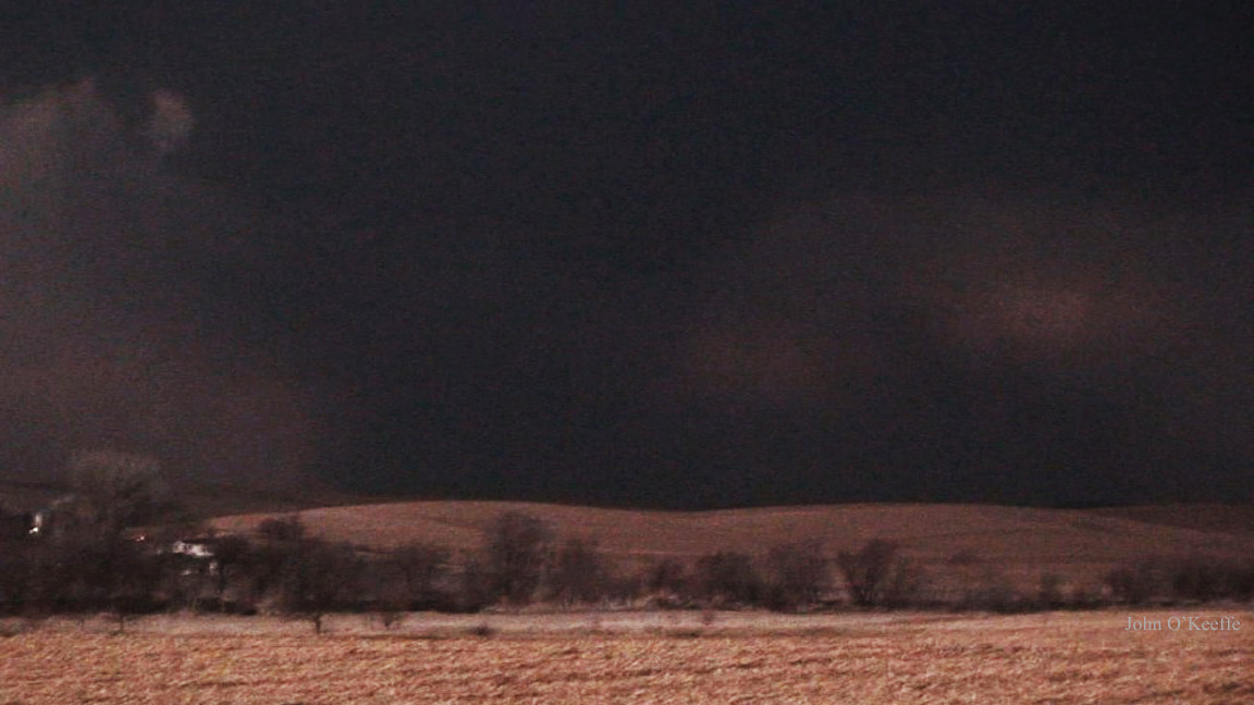
Summary: We left Olathe at 10am expecting to be in Great Bend by 3pm. Once we arrived in Great Bend we stopped and chatted with numerous chasers as we waited for the cap to break. A tornado watch was issued for the area but things weren't looking to promising as there was little cu activity occuring and it was getting to be past peak heating. A storm exploded down in NW Oklahoma near Woodward and dropped a tornado. With nothing else looking good we decided to at least head south in that direction to maybe intercept that storm eventually or pray a new storm fires further north. As we approached Medicine Lodge it was looking bleak and I went as far as to call it a bust. My dad however was more optimistic and noticed the left split of the Woodward storm strengthening to our SW near the KS/OK border south of Coldwater, KS. We quickly headed west hoping to get on the storm before dark. As we drove into Coldwater a tornado warning was issued for the storm and we could see a long inflow tail to our west. The chase was on! It wasn't long before we could see the base and it was an incredible supercell with amazing structure and a tornado appeared imminent. We were just east of Protection, KS when it put down the first truncated cone. We quickly turned north out of Protection as the last light of the day faded away. It wasn't long before we saw the next tornado of the day to our NW. It morphed from a cone to a stovepipe lasting nearly 10 minutes before roping out over the road. The next tornado occured as the other tornado was roping out however it occured to our NE and was quite brief. Minutes after the third tornado dissipated we had a new tornado quickly touch down to our NE and grow into a massive cone then stovepipe we would have to stop chasing this tornado however because of the road becoming too muddy. Little did we know this was the start of the Greensburg tornado. After backtracking back into Protection and then east to Coldwater we finally began blasting north of US183 towards the storm again. The structure from a distance was incredible and I just wish it could have happened in the daytime. We finally got a glimpse of the MASSIVE wedge as it was crossing the road to our north. We found a good place to pull off and watch the massive wedge move into Greensburg as numerous power flashes made us realize our worst fear that the town was taking a direct hit. As its widest the EF5 tornado was 1.7 miles wide and the inflow was incredible likely over 60MPH at times and were 4-5 miles from the tornado! The structure above was unlike anything I have ever seen as the size of the tornado was almost terrifying to see through the frequent lightning strikes. We finally moved closer as the tornado roped out back over the road. We then spent the next few hours assisting in clearing the road and search effort in Greensburg before calling it a night and heading to Pratt exhausted and shocked at what we had just seen. The following day would also prove to be interesting.
As tornado season is rapidly approaching I thought I'd add a chase log here or there from the past. Today's is from April 22, 2010 a great chase day in far W Kansas where we bagged 5 tornadoes between Lakin and Shallow Water.
Forecast: A surface low was located in E Colorado with a warm front stretching from SE Colorado into SW Kansas and a dryline extending from SE Colorado into SW KS into the TX Panhandle. Upper 50/low 60 dews were setting up along the dryline with nice SE/E 850mb winds aloft and a moderate 500mb winds out of the SW. This created great directional shear over a large area of the Southern Plains. We were torn between 2 targets 1)E TX Panhandle 2)SE CO/SW KS. Both targets looked good but SW Kansas had winds howling straight out of the east with due east 850s and WSW 500s creating more than a 90 degree turning with height. This allowed helicity values along the warm front to be in the 400-600m2/s2 range and with low 60F dews projected to push as far west as the KS/CO border it was an easy choice for my dad and I. SW Kansas or bust. Not to mention little to no chasers targeting this area so we would have it nearly to ourselves.
Summary: We spent the nighe before in Wichita not knowing if we would target the TX Panhandle or SW Kansas so if we were in Wichita we would have quicker access to either target. The following morning it was clear SE CO/SW KS was the play more specifically the Holly, CO to Syracuse, KS corridor. We left Wichita after breakfast for Syracuse, KS hoping to arrive by 2-3pm. We were making good time so we stopped in Dodge City for a longer lunch than anticipated and came out only to see an MD was issued for SE CO/SW KS mentioning a tornado watch would be issued. As we approached Garden City I got a call from Michael Carlson who said a storm had already fired near La Junta, CO and had produced 2 tornadoes. We immediately were dissipointed but knew the day was young so we kept on west. Then near Syracuse we got into some quarter sized hail that boosted our spirits followed by an elevated tornado warned storm near Granada, CO. We decided to needed to be further east as more storms fired near Syracuse our original target. After blasting east through a few more storms cores we positioned ourselves south of Lakin where a tornado warned storm was approaching.As it crossed the Arkansas River we could make out this massive EF2 wedge that quickly became rain wrapped shortly after this was taken south of Lakin looking west. Amazing structure on this storm as we position ourselves NE of the large tornado seen underneath near the center of the image. We are NE of Lakin here. The next tornado was a nice fat cone that we saw quite a distance as the meso occluded to our SW. This was near Deerfield, KS. The third tornado of the day was also the most photogenic it was a massive cone that slowly took its time roping out well SW of Friend, KS. The next tornado developed very quickly and was a large wedge that quickly became rain wrapped near due west of Friend, KS. The final tornado of the day was likely a satellite to the fourth tornado and was very brief lasting only seconds. Looking west from a mile north of Shallow Water, KS. After the final tornado dissipated the storm had become a monster HP that we didn't want to continue chasing so we let the RFD slam us which it did with 60+MPH winds and driving rain and then we drove on south to Garden City for some dinner before driving to McPherson, KS for the night in anticipation of another chase in Nebraska the following day.