Sunday, April 17, 2011

April 14 and The Rest of April

4/14/11 Osage County, OK Supercell
Above is a supercell I intercepted just south of the KS/OK border in Osage County on April 14 on a day I largely want to forget. Too much hesitation on my part trying to decide which storm to intercept cost me the Burbank tornado missing it by minutes. The storm quickly went to crap shortly after I arrived from what appeared to be from too many storms and weak winds at the mid levels. I wouldn't liked to have been in SE Oklahoma where stronger upper level winds were and the were the jet stream had a nice divergence but time kept me further north.

This system was incredible producing near 250 tornado reports between April 14-16 from KS/OK to MS/AL and NC/SC/VA. This was a historic outbreak for sure!

Looking ahead there is a couple of systems moving in on Tuesday and Friday but neither look very good chase wise but severe weather is likely. The last week in April though is looking appetizing in the long range with several potent setups over the S Plains. Very far out now but this time of the year the long range is typically quite accruate depicting a general trend in which this case is several severe weather setups.

Thursday, April 14, 2011

Chase Today Target: SE Kansas

Today is looking like a potentially volitle day over much of E Kansas and E Oklahoma. I am really liking the KS/OK border area where 60F dews seem likely with good Cape and it is close to the stronger LLJ with 50knts out of the SE really making me smile. Even upper 50 dews can get the job done today and with the RUC and HRRR agreeing with this I think today could be good! I will be leaving around noon for my target.

Sunday, April 10, 2011

Mapleton, IA Tornado Video

Here is the video of yesterday's Mapleton, IA tornado.


April 9, 2011 Mapleton, IA Tornadic Supercell

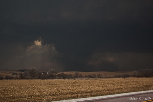
Great day in Iowa that we could've done a bit differently but I'm satisfied none the less! We left Olathe, KS at 10:30am with a target of Fremont, NE. We met up with Brandon Sullivan, Conner McCrorey, Donovon Gruner, and Brett Wright. We hung out just west of town and waited for storms to fire. Towers began going up just to our west so we went our seperate ways and went after them. We were sitting right under the storm when it developed and we were ahead of it as it slowly matured into a powerful supercell as it crossed the Missouri River west of Onawa, IA. Inflow was intense by now with winds sustained around 40MPH.

As we entered Onawa we were stopped by a train crossing the road and we quickly looked back to see a classic RFD/clear slot and rapid rotation on the wall cloud. The train moved on in the nick of time and we found a good spot just east of town to watch the now beast of a storm. Inflow continued to be insane and rotation was increasing in the middle of the supercell giving the storm a classic donut hole look. A fire possibly started by lightning was being pulled towards and upwards into the area of rotation just as a debris cloud began churning under the rotation. It quickly grew as a small funnel developed above it. Now I am not sure if this was a tornado or gustnado but for the sake of avoiding a flame war lets just call it a "tornadic" gustnado(?) I don't know what ever it was, it was pretty cool!

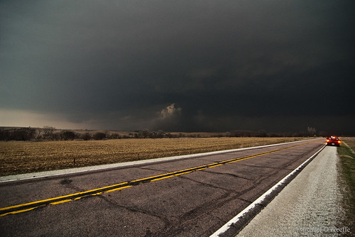
Classic structure as the supercell moves over Onawa.
4/9/11 Onawa, IA Supercell

Gustnado just east of Onawa.
4/9/11 Onawa, IA Gustnado

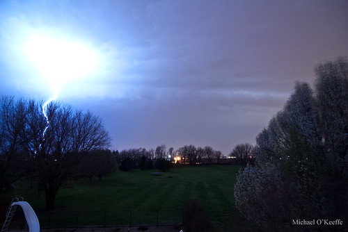
After moving east then north then east again we watched the storm cycle and get ready to produce again. The structure was pretty textbook of a strong tornadic supercell with a nice rounded base and several fast moving inflow tails with a nice clear slot on the backside. Soon a small nub funnel was seen to our north with what looked to be a large debris cloud underneath. We filmed it for several minutes as we tried to decide if it was a definite tornado and we were sure it was. We wanted to reposition to the north to get better visibility of the tornado and as we did the debris cloud really grew completely enshrouding the small cone funnel above it in dust. We got a nice view of the tornado once we found our north option and the thing was a large dusty mass. We didn't know it at the time but it was going through Mapleton at this time. We watched it dissipate before repositioned again to our east then north. Once dark fell we took a few lightning pictures and decided to call it a day since we had a 4 hour drive ahead of us and it was already after 8pm. We were a little dissapointed about missing the nighttime tornadofest but what can you do. At least we got to chase! I was more dissapointed about not being east or NE of the tornado like I like to be typically but at least I saw the tornado! We ended up back home around 1am.

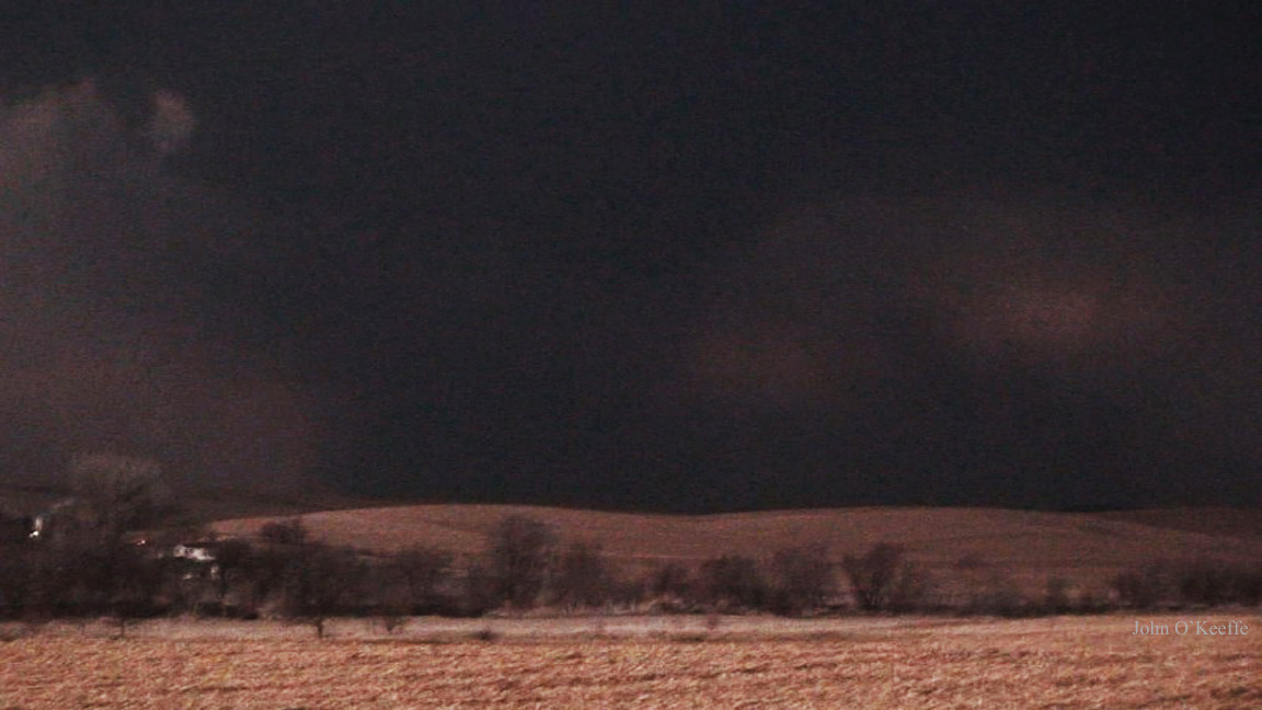
Classic structure looking NNW, you can see the Mapleton tornado developing just right of center.
4/9/11 Mapleton, IA Tornado Developing

The Mapleton tornado at its peak intensity.
4/9/11 Mapleton, IA Violent Tornado

Tornado roping out to our NW.
4/9/11 Mapleton, IA Tornado

Saturday, April 9, 2011

Awesome Chase in Iowa Today!

We nailed at least one large tornado today near Mapleton, IA in the NW part of the state that unfortunately did significant damage to town. Below is a quick teaser with more to come in the coming days.
4/9/11 Mapleton, IA Violent Tornado

First Chase of 2011!

Today begins the first chase of 2011 for my dad and I as we are heading north to W Iowa and E Nebraska to play a potent yet slightly capped setup. I have a feeling in my gut storms will be able to initiate today and if that happens with the strong instability, deep moisture, warm front, and classic shear profiles supercells with tornadoes are a good possibility. The 6z NAM, GFS, and HRRR all break out precip near the triple point in NE Nebraska so we will likely sit just along the river possibility as far north as Sioux City depending on where the warm front ends up.

Monday, April 4, 2011

April 3, 2011 Intense Hailstorm!

Last night we were slammed by an elevated severe storm that dumped golfball sized hail right here at our house in Olathe, KS down SW of Kansas City. The hail however caused significant damage to our house with the entire west facing side of our house completely blasted with large holes in the siding, major roof damage, as well as several busted windows, luckily we had the cars in the garage! It was great having the first storm of the season for me come basically right down my street and not even having to go anywhere hopefully a sign of things to come! Anyway below are a few pics with a video coming later.
4/3/11 Close Lightning
4/3/11 Golfball Sized Hail
4/3/11 Hail Damage to the House
4/3/11 Hail with Debris

The Video


Also the GFS and ECMWF continue to show a classic severe weather setup this Saturday over C/E Kansas. If it continues to look strong than it is more than likely our first real chase of 2011 will commence! Stay tuned...

Friday, April 1, 2011

First Chase Ops of 2011?

It appears looking at the GFS, ECMWF, and the NAM we are entering a very active pattern here in the early-mid April timeframe with our first chase of the 2011 season a very good possibility.

I will start with this weekend. Not much to say expect an extreme CAP with great shear and instability will create a non event expect for maybe some storms on the CF near/after dark in NE KS/N MO into C IA. The problem is just bad timing with the trough keeping the best forcing too far to the west. Monday looks decent in MS/AL/TN region with tornadoes a good bet but not very chaseable for obvious reasons.

I am really eyeing the April 8-9 timeframe with a monster well timed trough plowing into the Plains with 2 potentially good chase days. April 8 is looking like a classic early spring dryline chase in SC KS/W OK with dews in the mid-upper 60Fs, a nice easy to break cap (pray for this actually verify), S/SSE 850s, and 2500+ j/kg of CAPE. It is only a week out so hopefully it will verify but the models have been absolutely horrible anywhere further than 48hrs out this season. April 9 is looking primed in IA/MO/E KS possibly even into C/E OK. Right now the hotspot on April 9 looks to be C/E IA closer to the warm front and better shear.

Then in the WAAAAYYY long range April 14-16 looks very active with potentially widespread events on all 3 days first in the S/C Plains on April 14-15 with a the threat moving into the Upper/Mid Mississippi Valley.

It makes me cringe to think how far away these events are and how bad the models have been so far this season but with the fact it is April and moisture is more likely to be in numerous supply I am more confident that we are almost for sure going to see a nice chaseable setup in the Plains sometime in the next few weeks.